プロンプトライブラリ / Ultra-realistic top-down geographic map
Ultra-realistic top-down geographic map
作者:@TechieBySA
60001
テキストから画像へ
z-image-turbo
nano banana
nano banana pro
qwen image edit
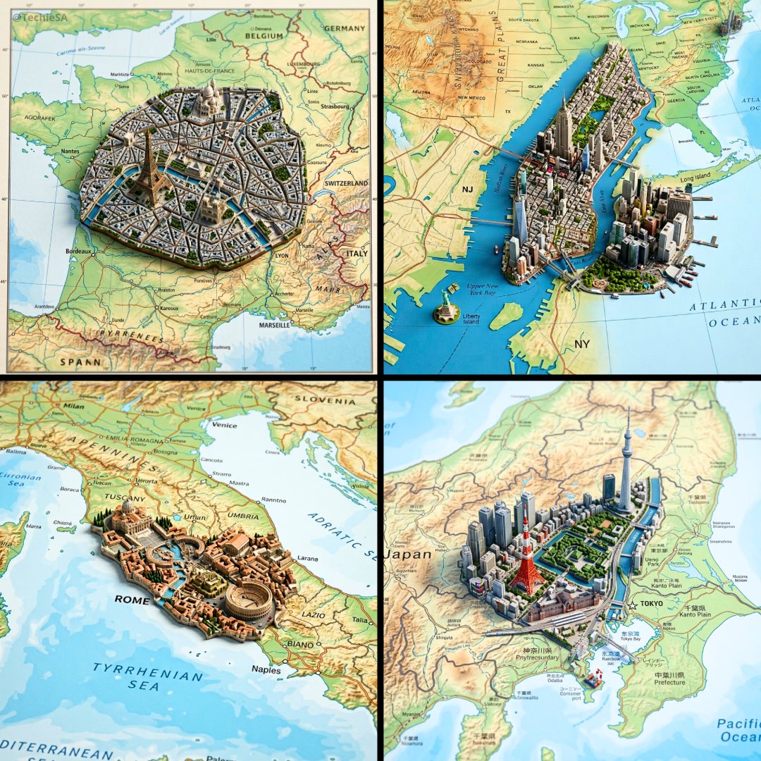
Ultra-realistic top-down geographic map with precise cartographic accuracy, clearly defining the true geographic context of [COUNTRY].
From the exact real-world coordinates of [CITY], a highly detailed miniature 3D diorama rises organically from the map surface, perfectly aligned with its true location.
The diorama features iconic architecture, signature natural landmarks, and authentic cultural elements of the city, seamlessly integrated into the map as if sculpted from it.
Physically accurate materials, realistic surface textures, and true-to-scale proportions.
Shallow depth of field with macro-lens realism, subtle atmospheric perspective.
Soft neutral studio lighting with controlled shadows to enhance depth and realism.
Cinematic composition, premium architectural-model photography style.
Ultra-sharp detail, high dynamic range, photorealistic finish.
Square 1:1 format, realistic scale, museum-quality visual output.
説明
z-image presents ultra-realistic top-down geographic maps with precise cartography and seamlessly integrated 3D dioramas, showcasing [CITY]'s true geography and cultural essence. Museum-quality visual experience with极致细节.
タグ
# museum-quality
# ultra-realistic map
# 3D diorama
# cartographic accuracy
# geographic visualization
# city landmarks
関連プロンプト
![Present a clear, 45° top-down isometric miniature 3D diorama of the iconic vehicle [VEHICLE NAME]](https://cdn.z-image.me/prompts/opennana/1766247348861-kq9htr.webp)
Present a clear, 45° top-down isometric miniature 3D diorama of the iconic vehicle [VEHICLE NAME]
Generate a 2x2 Grid of Pixar-Style 3D Character Dioramas Highlighting Overlooked Contemporaries
Highly Detailed 3D Bas-Relief Poster of City Landmarks
![Create an infographic image of [OBJECT], combining a realistic photograph or photoreal render of the object with technical annotation overlays placed directly on top.](https://cdn.z-image.me/prompts/opennana1769250684234-1188.jpg)
Create an infographic image of [OBJECT], combining a realistic photograph or photoreal render of the object with technical annotation overlays placed directly on top.
![Hyper-realistic 3D Render of a Plush Toy Animal Head [EMOJI🐱]](https://cdn.z-image.me/prompts/opennana/1766283320270-vt8btw.webp)
Hyper-realistic 3D Render of a Plush Toy Animal Head [EMOJI🐱]
![Create an Infographic Image of [LANDMARK]](https://cdn.z-image.me/prompts/opennana/1766270164097-3aigmy.webp)
Create an Infographic Image of [LANDMARK]
人気ツール
最も人気のあるクリエイティブツールを探索
Z-Image 編集
画像をアップロードし、一文で変化させます。
今すぐ試す
クリエイティブエンジン
一言で、AIが無限のプロンプトの創造性を提供します。
今すぐ試す
画像解析
画像をアップロードして、すぐにプロンプトを取得。
今すぐ試す
Z-Image LoRA
複数のLoRAモデルを組み合わせて、独自のAIアートワークを作成します
今すぐ試す
Z-Video
Generate creative videos from text or images with AI.
今すぐ試す
AI画像生成
テキストを即座に素晴らしい画像に変換します。
今すぐ試す
スタイルライブラリ
あなたの作品のために厳選されたアーティスティックスタイルを探索しましょう。
今すぐ試す
背景削除
AIで背景を瞬時に削除し、高精度な切り抜きを実現。
今すぐ試す
画質向上
画像を4K/8Kにアップスケールし、細部を鮮明に復元。
今すぐ試す
リフレーム
AIアウトペインティングであらゆる比率に背景を拡張。
今すぐ試す